

Freezing rain, snow and strong winds blast through Saskatchewan.

Snowfall Warning Ended
Environment Canada has ended a snowfall warning for the Prince Albert, North Battleford, Melfort and La Ronge areas and parts of northeast Saskatchewan.
An area of snow spread through parts of these regions Thursday as a low pressure system tracked in from Alberta.
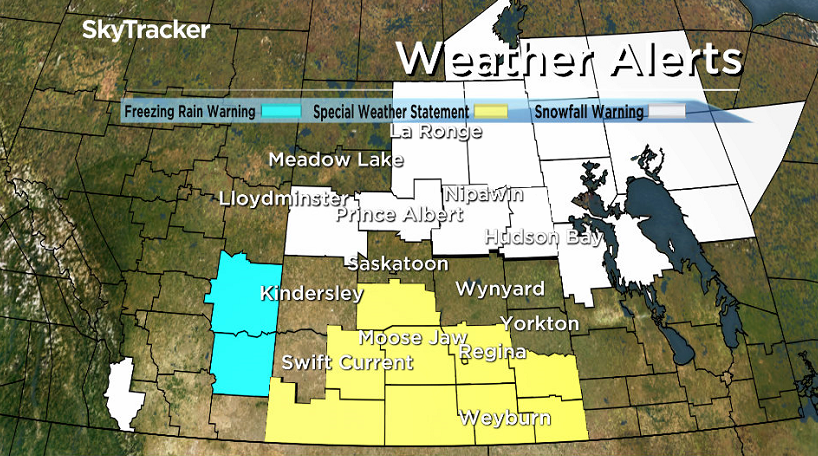
Ten centimeters of snow was expected along this line before the snow tapered off early Thursday evening.
Freezing rain warnings were also issued Thursday morning south of Saskatoon with a special weather statement for a risk of freezing rain across southern Saskatchewan.
For the latest weather alerts download the Global News Skytracker weather app for iPhone, iPad or Android.
Saskatoon Forecast
Thursday
Winds gusted upwards of 50 km/h Thursday morning as temperatures in minus double digits with wind chills around -20 to start the day.
Winds eased back a bit as areas north of the city were hit with heavy snow and south of the city by freezing rain as we warmed up to mid-minus single digits by noon.
Snow fell in the city during the afternoon as winds eventually shifted around to the northwest.
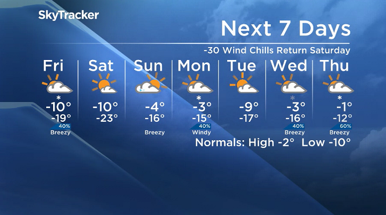
Friday
-25 is around what it’ll feel like with wind chill Friday morning under mostly cloudy skies with a chance of flurries, which will stick around for the majority of the day.
Clouds are expected to clear out into the evening hours after we rise up to an afternoon high around -11 degrees, which will feel like the mid-minus teens with wind chill with a breezy west-northwesterly wind at times, before we dive into the -20s overnight.
Weekend
An arctic high pressure system will drop in the cold air on Saturday, with the mercury diving back into the mid -20s with wind chills into the -30s to start the day before warming up toward minus single digits by afternoon with lots of sunshine.


The next system moves into Alberta on Sunday, which will push in some more clouds into Saskatchewan during the day, but also help boost temperatures up into mid-minus single digits for an afternoon high.
Work Week Outlook
That system will swing through on Monday with a pretty mild day with a chance of snow on Monday before we cool back down again for Tuesday as the temperature roller-coaster continues into next week.
Pablo Benitez took the Your Saskatchewan photo for Nov. 16 near Conquest:

Saskatoon weather outlook is your source for Saskatoon’s most accurate forecast and is your one stop shop for all things weather for central and northern Saskatchewan with comprehensive, in depth analysis that you can only find here.
- Budget 2024 failed to spark ‘political reboot’ for Liberals, polling suggests
- Train goes up in flames while rolling through London, Ont. Here’s what we know
- Peel police chief met Sri Lankan officer a court says ‘participated’ in torture
- Wrong remains sent to ‘exhausted’ Canadian family after death on Cuba vacation
Comments