

Saskatoon’s first snowfall of the season is slated to slide in!

Special Weather Statement
Environment Canada has issued a special weather statement for Saskatoon and all of central and southern Saskatchewan for rain, snow and strong winds Wednesday.
A weak low pressure system that moved through northern Saskatchewan on Tuesday brought a mix of rain and snow to northern parts of the province and above normal temperatures to the south before moving out Tuesday night.
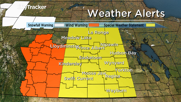
A second and stronger low pressure system will move through Saskatchewan on Wednesday and is expected to bring five to 10 centimetres of snow to the southern parklands and rain to parts of the northern grainbelt as it returns above normal temperatures to the southern half of the province.
A cold front associated with this low will begin to sweep in from Alberta late Wednesday with cold northwest winds in the wake of this front.
Generally wind gusts of 70 to 80 kilometres per hour are expected, but some regions may see gusts to 90 km/h.
These gusty north winds will bring widespread blustery conditions Wednesday night with light snow and local blowing snow.
Areas around the Cypress Hills are the most likely to see significant snow accumulations and strong winds.
Below normal temperatures will persist into Thursday.
- Budget 2024 failed to spark ‘political reboot’ for Liberals, polling suggests
- Train goes up in flames while rolling through London, Ont. Here’s what we know
- Peel police chief met Sri Lankan officer a court says ‘participated’ in torture
- Wrong remains sent to ‘exhausted’ Canadian family after death on Cuba vacation
A more details breakdown of this system’s impact on Saskatoon can be found below.
For the latest weather alerts download the Global News Skytracker weather app for iPhone, iPad or Android.
Saskatoon Forecast
Tuesday
It was a cool start to the day as temperatures slid back 3 degrees below freezing, which felt a cool as -7 with wind chill under clear skies.
By morning, mostly cloudy skies had built in along with a breezy south-southwesterly wind that helped boost us up into high single digits by noon.
Winds continued to pick up during the afternoon, with speeds as high as 35 km/h and gusts into the 50 to 60 km/h range under mostly cloudy skies with the mercury skyrocketing up into the upper teens.
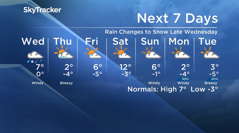
Wednesday
A low pressure system will swing in on Wednesday and bring in a risk of rain during the day after we climb up to a daytime high close to, if not into double digits.

Rain will switch over to some snow in the evening as temperatures cool behind a cold front sweeping through as northerly winds kick in up to 50 km/h or so with near warning level gusts of 80 to 90 km/h possible.

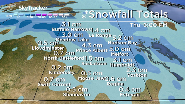
If cooler air injects into the system a little sooner and rain changes to snow earlier rather than later, this could be the city’s first accumulating snowfall of the season with a few centimetres possible.


Thursday-Friday
The snow should have eased by Thursday morning with some lingering clouds possible before we get into some afternoon sunshine with a daytime high struggling to get a few degrees above freezing.
Some warmer air will press in on Friday with temperatures springing back into mid single digits as a few more clouds push through.
Weekend Outlook
Another short-lived upper ridge of heat will help boost us up even further on Saturday with an afternoon high in low double digits under a mix of sun and cloud before another cold front sweeps through Sunday under mostly cloudy skies, knocking us back into mid-single digits for a daytime high.
Annette Wylie took this Your Saskatchewan photo for Oct. 24 in Wakaw:

Saskatoon weather outlook is your source for Saskatoon’s most accurate forecast and is your one stop shop for all things weather for central and northern Saskatchewan with comprehensive, in depth analysis that you can only find here.
Comments